


When filling out forms, most people use the mailing address. The classic “123 Main St SE, City, OR zipcode” format will be sufficient for most people when trying to identify the property, but the deed itself [the legal instrument that transfers ownership in the property] will need to have the legal description in order to be valid under ORS 93.600. Occasionally people will try to skip out on the legal description by just using a tax lot number in the deed [e.g. “Seller conveys to Buyer the property known as Tax Lot 123”], but ORS 93.600 expressly states, “Description by tax lot number shall not be adequate.” Nonetheless, the description of the property in the sale agreement itself doesn’t have to be as robust as a legal description unless the property is difficult to ascertain without the legal description (the Oregon REALTORS® sale agreement will bring in the legal description from the title company, see Section 38 of Form 1.1 but this must be reviewed and confirmed by the parties). This happens occasionally, where several parcels are attached to the same mailing address or when a single huge parcel is partitioned or subdivided into several smaller legal lots, at which point the legal description is more accurate in describing the parcel being sold.
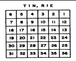
Legal descriptions are the shorthand for the geospatial location of property within the state. To start with, Oregon is generally oriented around the “Willamette Meridian” located at Longitude 122o 44’ 24” West and Latitude 45o 31’ 11” North. The meridian is literally a stone in the ground where the surveying chains originated for the north-south survey lines. Back in the early years of the United States, the Donation Land Claim Act and various other land claim acts increased the requirement for organized division of public lands, breaking public land into square miles [640 acres apiece] that could be given to settlers. The land was divided into townships and ranges, comprised of six mile by six mile grids of 36 square miles, where each square mile was known as a “section.” Monuments were placed every 40 chains [half mile] from the initial point to form quarter sections. [below image from A History of Rectangular Survey System, indicating Township 1 north of the Willamette Meridian, and Range 1 East of the Willamette meridian; basically the first square mile up and to the left of the Willamette stone]. The sections were numbered 1 through 36.
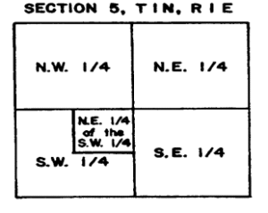
The Sections could then be broken up further into smaller pieces, creating partial fractional descriptions of geospatial location. E.g. Below is Township 1 North, Range 1 East, Section 5, as seen broken up into quarters, with the South West corner broken up further into two parcels: one that represents the North East ¼ of the South West ¼ of Section 5, T1N R1E, and one parcel that represents the remaining ¾ of the South West ¼ of Section 5, T1N R1E.
Through these Euclidean divisions of the land, Oregon was split up into squares and grid lines were established. Then, mankind got involved and parcels were split and divided and sold based on other lines, such as rivers, historic usage lines, hill lines, view, etc. The legal descriptions were occasionally broken up by lot, or by partition parcel, further splitting it away from square geometry. The parcels being sold would oftentimes have a “metes and bounds” description that traced the entire outline of the property plot. Some deeds will just farm the legal description out to other documents and reference various pages of public documents. Modern legal descriptions can be hyper complicated or quite simple, depending on the number of curves in the property line and the type of property:
Semi-Complicated description taken from Polk County public records [no rivers or curved lines here]:
“Beginning at a ½ inch iron rod on the Westerly Boundary Line of that Tract of Land covered in that real property sale contract between Bonded Mortgage Investors, Inc., Seller, and John I. and Celia M. Miller, Buyer, recorded in Book of Records 87, Page 988, Polk County, Oregon; said iron rod being the Northwesterly corner of that parcel of land quitclaimed to Walton E. and Marjorie J. Mildren by that Deed recorded in Book of Records 62, Page 808, Polk County, Oregon; said iron rod bears North 1 deg. 40 min. 19 sec. East 12.60 feet from a 1 ½ inch iron pipe marking the Southwest corner of Lot 1, Dallas Fruit Farm, Townships 7 and 8, Range 5 West of the Willamette Meridian in said county and state; and running thence North 1 Deg. 40 min. 19 sec. East 332.62 feet along the Westerly boundary line of said Miller Tract to a ½ inch iron pipe; thence South 88 deg. 25 min. 21 sec. East 369.48 feet parallel to the Northerly boundary line of said Mildred Parcel to a ½ inch iron pipe; thence North 37 deg. 29 min. 48 sec. East 345.73 feet to a ½ inch iron pipe on the Easterly boundary line of said Miller Tract; thence South 1 deg. 53 min. 02 sec. West, 612.61 feet along said Easterly boundary line to a ½ inch iron rod marking the Northeast corner of said Mildred Parcel; thence North 88 deg. 25 min. 21 sec. West 560.56 feet along the Northerly boundary line of said Mildred Parcel to the Point of Beginning.”
Simple description from Polk County public records:
“Lot numbered four (4), Block numbered four (4), Birchwood Terrace, Polk County, Oregon. There is an entire system for addressing disputes where the legal description is ambiguous. It’s highly advised that you or your client take those issues to a real property attorney if inaccuracy in the legal description is suspected.”
Tax Lot Identification Numbers, as stated earlier, are not sufficient for recordation, and attorneys advise avoiding usage of tax lot numbers as a description even when the parties do not intend to record the document. The tax lot is an administrative tool for the tax assessors office to use when figuring out property taxes. The tax assessor uses tax lots to maintain a map of parcels, for the purposes of identifying the tax assessment of that parcel; it’s generally going to be similar to the legal lot, but not always. The danger in using tax lots to describe a property comes in the land use standards of the state and counties. Typically, only one primary dwelling can be on each legal parcel; however, a single legal parcel may be described as two or three different tax lots. A buyer hoping to purchase a large plot and put up a couple houses for family or a couple houses to sell may find that the property is actually one large parcel that has to go through a subdivision, rather than the three parcels that the tax lot description implied.